
Maps of the campus were printed and brought to the agricultural class and students and myself set about determining the location of and size of suitable areas to conduct the inventory. Groups were made and were assigned to at least two specific areas out of 21 designated areas in the campus. All areas of the school were included, and students are going to seek permission to conduct their inventory work.
Below is a map of the campus divided into specific areas for the inventory, and student names have been allocated to specific areas to conduct the inventory.
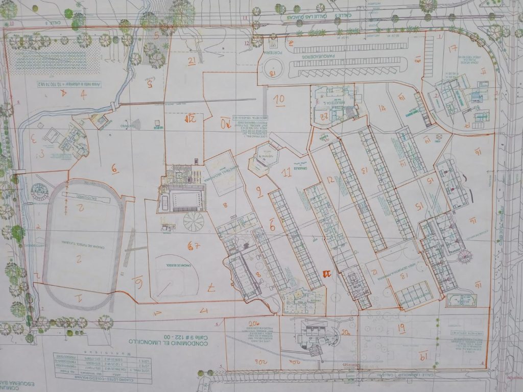
Table: Zoned areas with students working on those areas
| Zone(s) | Students | Areas |
| 1 &7 | Gabriella Gomez and Juan Esteban Martinez |
Path from Science building and J Block to the sports field, compost areas up until the river (1) Baseball field and surroundings (7) |
| 2 & 3 | Maria Alejandra Garcia and Tomas Jaramillo |
Cancha 1, upto and across the river to the boundary fence, up to the Kiosko (2). Director´s house (3) |
| 4, 5 & 6 | Xiomarra Covarrubias, Sara Escobar and Juan Jose Arellano |
Cancha 2 up to the river and boundary fences (4) The school garden (5) From the race track upto the school garden and cancha 2, including Cacao hill (6) |
| 8 & 9 | Martina Camacho and Melisa Londoño |
Middle School areas. All area between J, K and I blocks, swimming pool areas and Green Point areas. (8) High school area. All area between I and H block, up to SW side of Swall. (9) |
| 11 & 12 | Manuela Borerro & Juan Diego Arias |
Between high School and counselling offices including cafeteria – up to el Nido and Swall and Sunflowers. (11) Between G and F blocks, from the library to Mafalda and fence with El Nido (12). |
| 13 & 14 | Karime Assis and Alejandro Ortiz |
Primary blocks (F and E) around the back of the library to the Mango Tree (13). From transport and maintenance offices, and surrounding Rectoria (14). |
| 15 & 16 | Maria Jose Garcia and Jonah Keller |
From the north facing side of Rectoria towards pre primary between Blocks B and C (15). The back of Pre-primary up to and including the Atelier (16). |
| 18 & 17 | Laura Bustamente and Santiago Botero |
Maintenance areas, cafeteria (17). The main car park, Porteria 1 and alongside the library (18). |
| 19 & 20 a,b | Maria Antonia Cardona and Martin Mejia |
Primary football fields to the boundary fences (19). El Nido (20a) Limoncillo car park (20b) |
| 21 & 10 | Carmen Losada and Nicolas Ossma |
Between the library and the Swall up to the fence construction (10). Construction area bounded by Zones 5, 8, 10 and 18 (21) |
A session on how to collect data was convened and through question and answer sessions students developed ideas of how they were going to conduct the collection of data. Use of Google Sheets, Google Photos, to record trees is going to be used. In addition to this students are going to make notes about each tree they collect data on and mark this on their specific section of the map. This will lead to a map being drawn with all trees marked on to it.